
Of Idaho’s 107,651 miles of rivers, less than 1% are federally protected as Wild & Scenic.
We’re committed to protecting and restoring as many miles of Idaho’s rivers as possible.
In 1968, the Wild & Scenic Rivers Act (championed by Idaho Senator Frank Church) was signed into law, ensuring that rivers with outstanding and remarkable natural, recreational, and cultural features are preserved in their free-flowing condition for today and future generations. As of 2023, the National System protects 13,492 miles of 227 rivers in 41 states.
Wild & Scenic Designation Works: This Act is the greatest federal protection our cherished rivers have to maintain their outstanding and remarkable values and free-flowing character. Designation as a “Recreational” river under the WSRA would protect the free-flowing nature of the North Fork of the Payette by: preserving its outstanding and remarkable values maintaining the wide range of varied recreation in the area 67% of Western U.S. voters favor stronger safeguards for our rivers - PEW Charitable Trusts.
Of the initial eight rivers protected under the Wild & Scenic Act, two are located in Idaho: the Middle Fork of the Clearwater River and Middle Fork of the Salmon River. This legislation continues to protect and safeguard some of our nation’s most cherished rivers. However, many of our rivers remain unprotected.
Idaho has 107,651 miles of rivers, but only 891 miles of Idaho’s rivers are protected by the Wild & Scenic Rivers Act. Despite many more miles being considered eligible for designation, currently less than 1% are protected. Idaho Rivers United has worked to designate and protect 325 miles of river under the Wild & Scenic Rivers Act, guaranteeing these places retain their unique and exceptional qualities. We have many more miles to go, and IRU is committed to ensuring our rivers remain healthy and protected for generations to come.
Wild & Scenic Rivers Act Protections

The Wild & Scenic Rivers Act protects rivers with outstandingly remarkable natural, cultural, or recreational characteristics. Rivers that are ‘designated’ have permanent protection, ensuring they remain free-flowing and retain the characteristics that make them exceptional and unique.
Our Wild and Scenic Rivers Program focuses on strategic, high-priority river systems in Idaho. Our top priority campaigns include the Lower Salmon River, North Fork and South Fork of the Payette River, South Fork Salmon and tributaries, South Fork Boise River, Teton River, and tributaries of the Lochsa-Selway-Clearwater systems.
In Idaho, the Wilderness Act does not protect waterways, but the Wild & Scenic Act ensures protection.
Designation brings with it a Federal Reserved Water Right, which will be quantified after designation and is designed to protect enough water to protect river values.
Protections guarantee free flow, water quality, and outstandingly remarkable values.
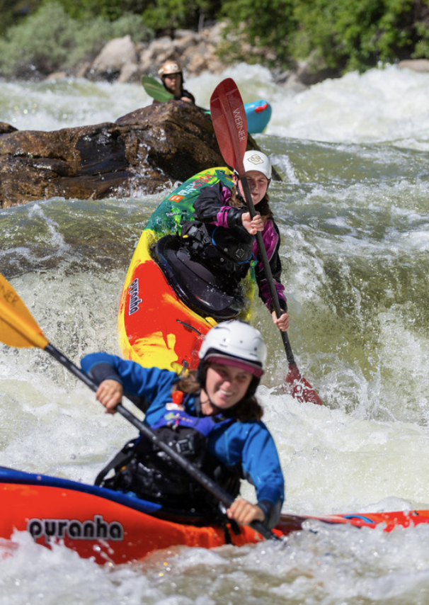
The North Fork of the Payette River
IRU was founded as “Friends of the Payette” working to protect the Payette River system from being dammed, before taking our mission statewide. This history gave way to Idaho Rivers United’s future river conservation work. This background is still rooted in the philosophy and river conservation strategies we implement today.
Eligibility & Suitability:
The North Fork of the Payette is unlike any other river in the region. Professional and international paddlers gravitate to the Class V section as a testing ground prior to embarking on global expeditions in search of first descents worldwide.
The North Fork also has friendly, calmer stretches of floating on the Cabarton section, making it one of the most popular day trips in the state.
This river also serves as an economic driver for local communities and has hosted the North Fork Championship, widely regarded as the most challenging whitewater paddling competition in the world.
The Lower Salmon River
IRU is working in collaboration with the Nez Perce Tribe to establish permanent protected status for the Lower Salmon River through federal processes.
Traversing the heart of the traditional lands of the Nez Perce, the Lower Salmon River holds vital cultural monuments and value for the Nez Perce people. Within the Lower Salmon, there are hundreds of historical sites, including Coopers Ferry, which recently provided evidence of occupation more than 16,000 years ago, supporting a theory of human migration into the interior of North America along coastlines and river corridors.
Descending over 1,000 feet before meeting the Snake River, this undammed section of river is truly remarkable and worthy of permanent protection. Comprising the final portion of one of the longest undammed rivers in North America, and the longest within the Columbia basin, the Lower Salmon River provides critical habitat for Endangered Species Act-listed anadromous salmonids and supports other native fish species such as white sturgeon, westslope cutthroat trout, redband trout, and lamprey.
The river corridor also boasts numerous sites that tell the story of the discovery of gold in Idaho and the broader west as well as the miners that flocked to the region in their pursuit. In more recent times, the river has served as the backbone for the economy of many towns and cities that have seen industry shift away from extractive industries to those that revolve around tourism and the natural resources that abound along the river corridor
In addition to collaboration with the Nez Perce Tribe, we are working closely with our national partners at American Rivers and American Whitewater on this campaign.
Additionally, IRU is working to secure Wild and Scenic River protections for the South Fork of the Boise River, Teton River, and North Fork of the Payette River.
Each of these rivers has outstanding and remarkable values, and we are actively working to have these rivers protected under the Wild and Scenic Rivers Act. We are a leadership team member of the Wild and Scenic Rivers Coalition, and are helping support Wild and Scenic designations across the West, including the Owyhees, Cascades, Gila, and Dolores campaigns.

Idaho is long over due for new Wild & Scenic River designations.
The last one was in 2009 when the Owyhee canyon lands were protected. Along with 517,000 acres of newly designated wilderness, the bill preserved 325 miles of river as Wild & Scenic.
The Owyhee canyonlands of southwestern Idaho form a dramatic and unique landscape known for its deep river canyons and vast expanses of sagebrush-steppe habitat, both of which offer opportunities for solitude and recreation. The region supports small ranching communities that utilize the vast rangeland. The landscapes, rivers, and fish and wildlife of the region have supported Northern Paiute, Bannock, and Shoshone tribal people since time immemorial.
Those who rely on and enjoy visiting and experiencing the special beauty of the Owyhee canyon lands came together to form the Owyhee Initiative (OI), a diverse coalition of stakeholders, including Idaho Rivers United, that were determined to protect and preserve the incredible area. This effort culminated in the 2009 Owyhee Initiative Implementation Act, which was introduced by Senator Mike Crapo.
The designations protected a larger portion of the Owyhee River watershed, adding on to the lower stretches of the Owyhee system that have been designated W&S since the 1980’s. This includes upper portions of the main river, the South Fork Owyhee, and tributaries such as Deep Creek and Battle Creek. Additionally, rivers in the Bruneau-Jarbidge, Big Jacks, and Little Jacks systems are now protected thanks to the work of the OI.
The Owyhee canyon country is some of the last, best intact sagebrush-steppe habitat in the country. It supports healthy populations of sage-grouse, pronghorn, deer, and elk. The rugged canyons are home to California bighorn sheep, raptors, rare plants, and native redband trout. The Jarbidge River is home to the southernmost population of bull trout on Earth.
Many river systems in this truly wild place were preserved in the 2009 bill for the use and enjoyment of future generations. But threats remain to the area, including the expansion of military aircraft operations. IRU will work alongside OI stakeholders and local communities to continue the stewardship and protection of the Owyhee canyon lands.
Owyhee (March 30, 2009) https://www.rivers.gov/rivers/owyhee-nf-id.php
Owyhee: The Owyhee River from the Idaho-Oregon State border to the upstream boundary of the Owyhee River Wilderness. ORVs: Ecological, Fisheries/Aquatic Species, Geologic, Recreational, Scenic, Wildlife. Wild=67.3 miles
SF of Owyhee: The South Fork of the Owyhee River upstream from its confluence with the Owyhee River to the upstream boundary of the Owyhee River Wilderness at the Idaho Nevada State border. Wild=30.2 miles; Recreational=1.2 miles. ORVs: Cultural, Fisheries/Aquatic Species, Geologic, Recreational, Scenic, Wildlife.
NF of Owyhee: The North Fork of the Owyhee River from the Idaho-Oregon State border upstream to the upstream boundary of the North Fork Owyhee River Wilderness. ORVs: Ecological, Cultural, Fisheries/Aquatic Species, Geologic, Recreational, Scenic, Wildlife. Wild=15.1 miles; Recreational=5.7 miles.
The Wild & Scenic Rivers proposal included in S. 2833 was developed by the Owyhee Initiative Work Group, which included Idaho Rivers United and other conservation groups, recreationists, ranchers, tribes and county officials. The group was formed by the Owyhee County Commission in 2001 to find collaborative solutions for land use conflicts, protection of landscape and river resources, protection of cultural resources, and to promote economic stability and protect the way of life now enjoyed by Owyhee County residents and its ranching community. (From OI IRU Fact Sheet)
Proposed for designation are all or key segments of: The East Fork (also known as the Main Stem) Owyhee, The Bruneau, The Jarbidge, North Fork Owyhee, South Fork Owyhee, Little Owyhee, Little Jacks Creek, Big Jacks Creek, West Fork Bruneau, Sheep Creek, and key Owyhee tributaries: Deep Creek, Battle Creek, Red Canyon Creek, Dickshooter Creek, Pole Creek and Camas Creek.
There are three different classifications of protection — wild, being the least developed and most protected; next comes scenic, then recreational. Most of the rivers proposed for designation in S. 2833 fall under the ‘wild’ classification. New development in river corridors must be consistent with its classification.
What was actually designated in 2009 from S.2833: Bruneau River, West Fork of the Bruneau River, Jarbidge River, Owyhee, South Fork of the Owyhee, North Fork of the Owyhee, Big Jacks creek. Tributaries: Deep creek, Dickshooter creek, Battle creek, Duncan creek, Red Canyon, Camas creek,